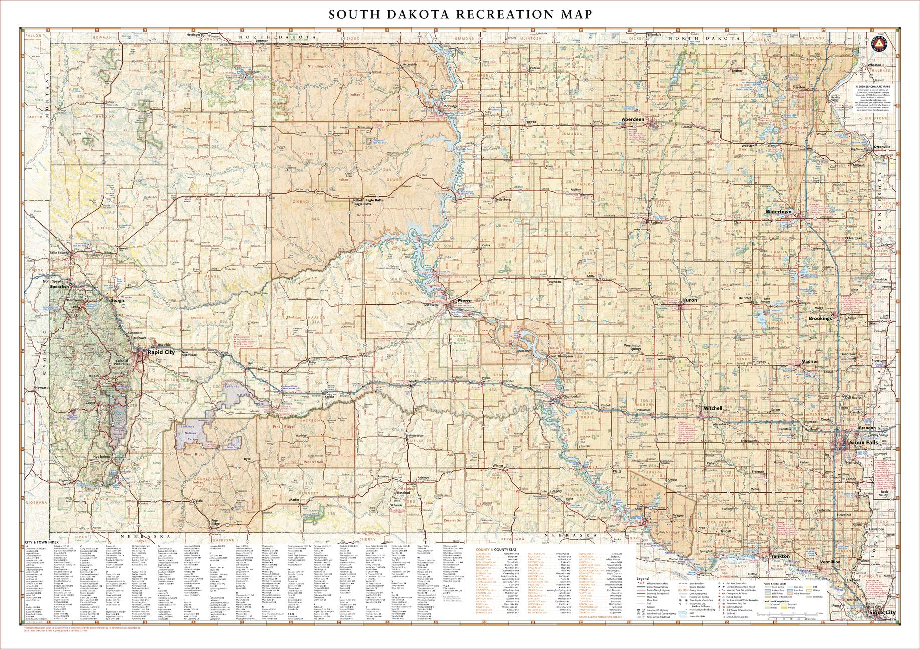
South Dakota Recreation 972 x 686mm Wall Map
🏞 South Dakota Recreation Wall Map – 2022 Edition
Published: 2022 | Scale: 1:636,000 | Size: 972 mm (W) × 686 mm (H)
From the majestic granite peaks of the Black Hills to the rolling prairies and river valleys of the east, South Dakota offers a landscape as diverse as its history. This beautifully detailed wall map highlights the state’s public lands, scenic byways, and recreation hotspots, from world-renowned Mount Rushmore National Memorial and Deadwood’s Wild West charm to Sturgis, Badlands National Park, and the capital city of Sioux Falls.
Whether you’re planning a road trip, mapping out hunting or fishing spots, or simply seeking a stunning wall display, this map captures the essence of The Mount Rushmore State in both function and style.
🗺 Key Features
-
Full State Coverage – From the Wyoming border to the eastern plains and from North Dakota to Nebraska.
-
Public Lands & Protected Areas – National parks, forests, monuments, state parks, and recreation areas clearly marked.
-
Road & Highway Detail – Interstate routes, scenic drives, and back roads for exploring.
-
Topographic Shading – Shows mountain ranges, valleys, and river systems in vivid relief.
-
Clean, Legible Cartography – Designed for both navigation and display.
📐 Size & Scale
| Dimensions | Scale | Edition |
|---|---|---|
| 972 × 686 mm | 1:636,000 | 2022 |
🖌 Premium Material & Display Options
| Format | Description |
|---|---|
| Paper (160 gsm) | Heavyweight matte-coated stock — ideal for framing under glass. |
| Laminated | Encapsulated in 80-micron gloss laminate — waterproof, tear-resistant, and whiteboard marker compatible. |
| Laminated + Hang Rails | Professionally mounted with natural timber rails and a hanging cord for easy display. |
| Canvas (395 gsm) | Museum-grade matte canvas with archival pigment inks — rich texture and fade-resistant quality. |
| Canvas + Hang Rails | Canvas mounted with lacquered timber rails for a premium, ready-to-hang presentation. |
Note: Please allow up to 10 working days for delivery of hang-railed maps due to custom mounting.
🎯 Ideal For
-
Travellers & Road Trippers – Navigate scenic drives from the Black Hills to the Missouri River.
-
Outdoor Enthusiasts – Locate campgrounds, hiking trails, fishing access, and wildlife viewing areas.
-
Educators & Visitor Centres – A visually engaging reference for classrooms and tourism hubs.
-
Collectors – Complements the full U.S. recreation wall map series.
🌟 Why Choose This Map
-
Comprehensive State Detail – From iconic attractions to hidden natural gems.
-
Dual Purpose – A reliable planning tool and a beautiful piece of wall art.
-
Premium Craftsmanship – Crisp printing, archival materials, and lasting durability.
-
Proudly Made in Australia – Produced to the highest cartographic and printing standards.
The South Dakota Recreation Wall Map is more than a map — it’s an inspiring portrait of a state that blends natural beauty, history, and adventure. Perfect for display in the home, office, or anywhere that celebrates the American outdoors.
Original: $57.94
-65%$57.94
$20.28Product Information
Product Information
Shipping & Returns
Shipping & Returns
Description
🏞 South Dakota Recreation Wall Map – 2022 Edition
Published: 2022 | Scale: 1:636,000 | Size: 972 mm (W) × 686 mm (H)
From the majestic granite peaks of the Black Hills to the rolling prairies and river valleys of the east, South Dakota offers a landscape as diverse as its history. This beautifully detailed wall map highlights the state’s public lands, scenic byways, and recreation hotspots, from world-renowned Mount Rushmore National Memorial and Deadwood’s Wild West charm to Sturgis, Badlands National Park, and the capital city of Sioux Falls.
Whether you’re planning a road trip, mapping out hunting or fishing spots, or simply seeking a stunning wall display, this map captures the essence of The Mount Rushmore State in both function and style.
🗺 Key Features
-
Full State Coverage – From the Wyoming border to the eastern plains and from North Dakota to Nebraska.
-
Public Lands & Protected Areas – National parks, forests, monuments, state parks, and recreation areas clearly marked.
-
Road & Highway Detail – Interstate routes, scenic drives, and back roads for exploring.
-
Topographic Shading – Shows mountain ranges, valleys, and river systems in vivid relief.
-
Clean, Legible Cartography – Designed for both navigation and display.
📐 Size & Scale
| Dimensions | Scale | Edition |
|---|---|---|
| 972 × 686 mm | 1:636,000 | 2022 |
🖌 Premium Material & Display Options
| Format | Description |
|---|---|
| Paper (160 gsm) | Heavyweight matte-coated stock — ideal for framing under glass. |
| Laminated | Encapsulated in 80-micron gloss laminate — waterproof, tear-resistant, and whiteboard marker compatible. |
| Laminated + Hang Rails | Professionally mounted with natural timber rails and a hanging cord for easy display. |
| Canvas (395 gsm) | Museum-grade matte canvas with archival pigment inks — rich texture and fade-resistant quality. |
| Canvas + Hang Rails | Canvas mounted with lacquered timber rails for a premium, ready-to-hang presentation. |
Note: Please allow up to 10 working days for delivery of hang-railed maps due to custom mounting.
🎯 Ideal For
-
Travellers & Road Trippers – Navigate scenic drives from the Black Hills to the Missouri River.
-
Outdoor Enthusiasts – Locate campgrounds, hiking trails, fishing access, and wildlife viewing areas.
-
Educators & Visitor Centres – A visually engaging reference for classrooms and tourism hubs.
-
Collectors – Complements the full U.S. recreation wall map series.
🌟 Why Choose This Map
-
Comprehensive State Detail – From iconic attractions to hidden natural gems.
-
Dual Purpose – A reliable planning tool and a beautiful piece of wall art.
-
Premium Craftsmanship – Crisp printing, archival materials, and lasting durability.
-
Proudly Made in Australia – Produced to the highest cartographic and printing standards.
The South Dakota Recreation Wall Map is more than a map — it’s an inspiring portrait of a state that blends natural beauty, history, and adventure. Perfect for display in the home, office, or anywhere that celebrates the American outdoors.