Oregon National Geographic Folded Map
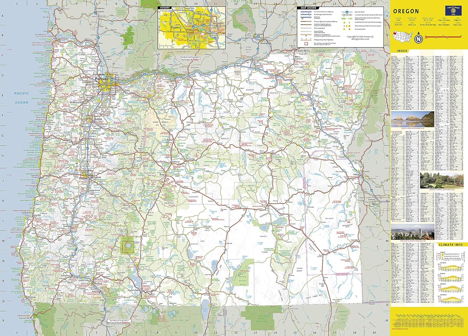
🌲 Oregon – National Geographic State Guide Map
Waterproof • Tear-Resistant • Travel Map
From the rugged Pacific coastline to the towering peaks of the Cascade Range and the wide-open beauty of the High Desert, the National Geographic Oregon Guide Map is the ultimate travel companion for exploring the Beaver State. Meticulously researched and beautifully designed, it blends clear, detailed cartography with practical travel information—perfect for road trips, outdoor adventures, and cultural exploration.
🗺 Comprehensive Statewide Coverage
-
Road Network Clarity – Interstates, highways, scenic byways, and local roads
-
Toll Road & Ferry Markings – Easy-to-spot designations for planning travel routes
-
Mileage Indicators – Distances in miles shown on major highways for accurate trip planning
-
Travel Essentials – Airports, hospitals, visitor centres, public campsites, ski areas, and recreation zones clearly marked
📍 Detailed Insets for Key Cities & Regions
-
Eugene – Vibrant university city and gateway to wine country
-
Salem – State capital with historic landmarks and Willamette Valley access
-
Portland – Comprehensive city map plus detailed downtown map for navigating its bridges, districts, and riverfront
-
Crater Lake National Park – Iconic volcanic lake with hiking, viewpoints, and scenic drives
-
Columbia River Gorge – World-class hiking and waterfall trails along the Washington–Oregon border
-
Rogue–Umpqua Scenic Byway – A mapped route through Southern Oregon’s natural beauty
🌟 Special Features
-
Points of Interest – Historic sites, natural landmarks, museums, and cultural attractions
-
National & State Parks – Recreation areas, campgrounds, and trailheads marked for quick reference
-
Events Calendar – Seasonal highlights to help you time your visit
-
Driving Distance Chart – Quick reference for planning multi-stop journeys
-
Park Service Site Chart – Overview of facilities, accessibility, and visitor services
📐 Product Specifications
| Feature | Detail |
|---|---|
| Publisher | National Geographic Maps |
| Map Type | Folded State Guide Map |
| Material | Waterproof, tear-resistant synthetic paper |
| Scale | Statewide with multiple detailed insets |
| Format | Double-sided |
| Flat Size | 660 mm x 940 mm (26" x 37") |
| Folded Size | 102 mm x 229 mm (4" x 9") |
| Order Info | Order on Demand – Please allow 7–10 working days for delivery |
🎯 Ideal For
-
Road trippers tracing Oregon’s scenic routes
-
Outdoor enthusiasts heading for hiking, skiing, or coastal adventures
-
Nature lovers exploring waterfalls, volcanoes, and wilderness areas
-
Cultural travellers visiting Oregon’s wine country, historic towns, and artisan communities
With National Geographic’s Oregon Guide Map, you’ll have the perfect blend of navigation, inspiration, and durability—your go-anywhere, see-everything tool for exploring one of America’s most diverse and breathtaking states.
Original: $21.70
-65%$21.70
$7.59Product Information
Product Information
Shipping & Returns
Shipping & Returns
Description
🌲 Oregon – National Geographic State Guide Map
Waterproof • Tear-Resistant • Travel Map
From the rugged Pacific coastline to the towering peaks of the Cascade Range and the wide-open beauty of the High Desert, the National Geographic Oregon Guide Map is the ultimate travel companion for exploring the Beaver State. Meticulously researched and beautifully designed, it blends clear, detailed cartography with practical travel information—perfect for road trips, outdoor adventures, and cultural exploration.
🗺 Comprehensive Statewide Coverage
-
Road Network Clarity – Interstates, highways, scenic byways, and local roads
-
Toll Road & Ferry Markings – Easy-to-spot designations for planning travel routes
-
Mileage Indicators – Distances in miles shown on major highways for accurate trip planning
-
Travel Essentials – Airports, hospitals, visitor centres, public campsites, ski areas, and recreation zones clearly marked
📍 Detailed Insets for Key Cities & Regions
-
Eugene – Vibrant university city and gateway to wine country
-
Salem – State capital with historic landmarks and Willamette Valley access
-
Portland – Comprehensive city map plus detailed downtown map for navigating its bridges, districts, and riverfront
-
Crater Lake National Park – Iconic volcanic lake with hiking, viewpoints, and scenic drives
-
Columbia River Gorge – World-class hiking and waterfall trails along the Washington–Oregon border
-
Rogue–Umpqua Scenic Byway – A mapped route through Southern Oregon’s natural beauty
🌟 Special Features
-
Points of Interest – Historic sites, natural landmarks, museums, and cultural attractions
-
National & State Parks – Recreation areas, campgrounds, and trailheads marked for quick reference
-
Events Calendar – Seasonal highlights to help you time your visit
-
Driving Distance Chart – Quick reference for planning multi-stop journeys
-
Park Service Site Chart – Overview of facilities, accessibility, and visitor services
📐 Product Specifications
| Feature | Detail |
|---|---|
| Publisher | National Geographic Maps |
| Map Type | Folded State Guide Map |
| Material | Waterproof, tear-resistant synthetic paper |
| Scale | Statewide with multiple detailed insets |
| Format | Double-sided |
| Flat Size | 660 mm x 940 mm (26" x 37") |
| Folded Size | 102 mm x 229 mm (4" x 9") |
| Order Info | Order on Demand – Please allow 7–10 working days for delivery |
🎯 Ideal For
-
Road trippers tracing Oregon’s scenic routes
-
Outdoor enthusiasts heading for hiking, skiing, or coastal adventures
-
Nature lovers exploring waterfalls, volcanoes, and wilderness areas
-
Cultural travellers visiting Oregon’s wine country, historic towns, and artisan communities
With National Geographic’s Oregon Guide Map, you’ll have the perfect blend of navigation, inspiration, and durability—your go-anywhere, see-everything tool for exploring one of America’s most diverse and breathtaking states.